Geographic Information Systems (GIS) have moved from being niche tools for cartographers to becoming central pillars in how cities expand, adapt, and thrive. Modern municipalities rely on GIS for City Planning and Growth to address complex challenges, such as rapid urbanization, climate resilience, and equitable resource distribution, while ensuring long-term sustainability. Cities that integrate GIS for Sustainable Communities into their planning process often see clearer zoning strategies, smarter infrastructure investments, and stronger engagement with residents.
Future GIS Applications
- Connecting data to action: GIS links spatial information with real-world planning decisions, making urban growth more efficient and equitable.
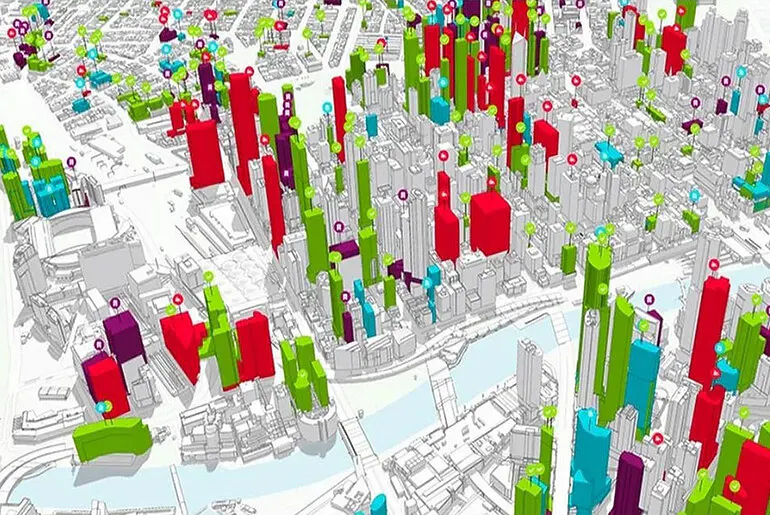
- Unified visualization tools: Modern platforms help visualize zoning, land use, transportation, and environmental risks in one place.
- Proven impact through case studies: Cities that adopt GIS report improved infrastructure planning, reduced costs, and stronger citizen engagement.
- Avoiding common pitfalls: Outdated datasets and failure to integrate with compliance standards remain key challenges.
- Scalable frameworks: Practical approaches exist for both small municipalities and large metropolitan regions, ensuring accessibility regardless of budget or size.
What Is GIS for City Planning and Growth?
At its core, GIS is a digital framework that integrates mapping with analytical data. For city planning, it enables:
- Land use analysis: Understanding where housing, commercial spaces, or green areas should expand.
- Infrastructure mapping: Planning transportation networks, utilities, and public services.
- Risk assessment: Identifying flood zones, earthquake-prone areas, and climate vulnerabilities.
- Community engagement: Providing residents with interactive maps to understand upcoming projects.
In a 2024 report from the U.S. Department of Transportation, cities using GIS tools reduced project planning time by nearly 20%. That translates into faster approvals and better allocation of taxpayer funds.
How GIS Shapes Modern Urban Growth
1. Land Development and Zoning
GIS platforms layer zoning codes, population density, and transportation access into one interactive view. For example, a mid-sized city may use GIS to decide whether to allow mixed-use buildings in a growing neighborhood.
2. Infrastructure and Transportation
Public transit routes, bike lanes, and highway expansions benefit from GIS data that shows traffic flow and commuter behavior. Cities like Portland and Singapore rely on these insights to reduce congestion and promote sustainable travel options.
3. Environmental Sustainability
GIS highlights wetlands, forests, and air-quality zones. By integrating this data, cities avoid costly mistakes such as approving development in sensitive ecosystems. In California, state law now requires GIS-based environmental impact assessments before large housing projects.
4. Social Equity in Planning
Data visualizations show where underserved communities lack access to healthcare, schools, or public transit. This allows decision-makers to target investments where they are most needed.
Practical Examples of GIS in Action
- New York City uses GIS to monitor construction permits and prevent zoning violations.
- Houston integrates floodplain data into new housing developments after Hurricane Harvey.
- Barcelona utilizes GIS dashboards to track the allocation of green spaces per resident, ensuring an equitable distribution.
These examples illustrate that GIS is not just about maps, it’s about connecting geography with human priorities.
Step-by-Step: Using GIS in Planning Workflows
Implementing GIS effectively in city planning requires more than just maps, it’s a structured workflow that turns raw data into reliable decisions. Each stage builds on the previous one to create a complete, living system for smarter urban management.
1. Data Collection
Start by gathering comprehensive datasets such as satellite imagery, census data, traffic sensors, and environmental monitoring results. The broader the data pool, the more accurate the analysis.
2. Data Cleaning
Remove duplicate entries, align spatial coordinates, and validate timestamps. Clean data prevents misleading insights and ensures models reflect real-world conditions.
3. Layer Integration
Overlay datasets like land use, transportation networks, flood zones, and air quality. This layered view highlights relationships that wouldn’t be visible in isolation, for example, how new housing projects might affect traffic congestion or green space distribution.
4. Analysis
Run simulations and predictive models to test different urban growth scenarios. Planners can analyze traffic demand, energy needs, or flood risk under varying conditions. This step is where raw information becomes actionable intelligence.
5. Decision Output
Convert findings into practical formats such as interactive dashboards, heat maps, or 3D city models. These outputs support communication with stakeholders, whether city councils, developers, or the general public.
6. Monitoring
Cities are dynamic, so GIS workflows must stay active. Regularly update datasets to reflect changes in population, land use, and climate impacts. Continuous monitoring ensures that planning decisions remain relevant and effective.
Pros and Cons of Using GIS for Planning
| Pros | Cons |
| Enhances transparency and community trust | Requires skilled staff and training |
| Speeds up project approval timelines | High upfront software costs |
| Reduces risk of costly planning mistakes | Risk of biased outcomes if the data is incomplete |
| Enables scenario modeling for future growth | Sensitive data requires strong protection |
Common Mistakes to Avoid
- Overreliance on old data: A map from five years ago may ignore new developments.
- Lack of public involvement: Failing to share GIS dashboards reduces community trust.
- Ignoring compliance: Failing to align with federal and state guidelines can delay projects.
- Fragmented systems: Using multiple unlinked tools creates confusion instead of clarity.
FAQs
1. How does GIS improve city planning efficiency?
GIS reduces duplication of work and integrates multiple datasets, cutting planning timelines by up to 20%.
2. What role does GIS play in sustainable growth?
It ensures cities expand without harming critical ecosystems, aligning growth with sustainability.
3. Is GIS only for large metropolitan areas?
No. Small towns use open-source tools like QGIS to manage zoning and infrastructure.
4. Can GIS help during natural disasters?
Yes. GIS maps show evacuation routes, emergency shelters, and flood-prone zones.
5. How often should GIS data be updated?
Best practice suggests quarterly updates for high-growth areas and annual updates for stable zones.
6. What skills do city planners need to use GIS?
Basic GIS literacy, data analysis skills, and familiarity with local compliance standards.
Moving Forward with Smarter Growth
Cities that adopt GIS transform abstract planning into actionable decisions. Whether it’s managing rapid housing demand, building climate-resilient infrastructure, or ensuring equity, GIS gives leaders the clarity they need. The next step for municipalities is not whether to use GIS, but how deeply to embed it across departments.
Smarter growth requires breaking down silos and aligning every decision, from zoning approvals to emergency response, with geospatial intelligence. When transportation officials, environmental regulators, and housing planners all work from the same GIS-powered platform, cities can avoid costly overlaps and move faster on projects that matter most to residents.
Equally important is ensuring accessibility. Future-ready municipalities will extend GIS beyond city hall, allowing communities, businesses, and universities to contribute data and benefit from insights. This shared ecosystem fosters innovation and strengthens trust.
In short, embedding GIS across urban governance isn’t just a technical upgrade; it’s a cultural shift toward transparency, resilience, and smarter growth. Cities that embrace this approach will be better equipped to thrive in a future defined by complexity and change.